Integrated Systems
-
 Original price 21,130.00 USD - Original price 21,130.00 USDOriginal price21,130.00 USD21,130.00 USD - 21,130.00 USDCurrent price 21,130.00 USD
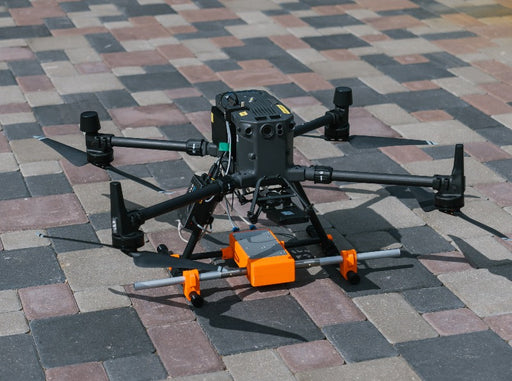
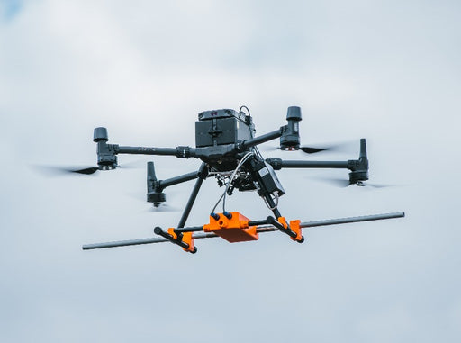
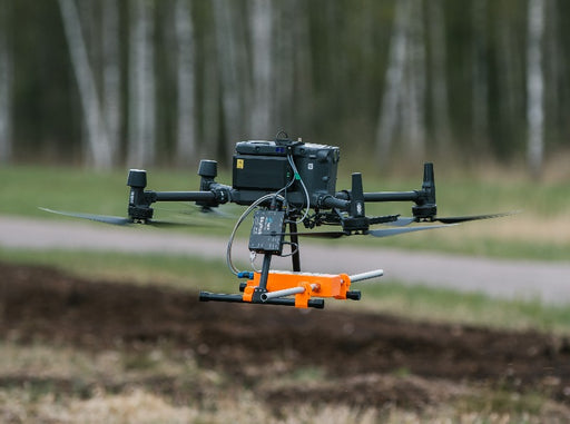
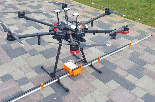
GPR system: Radar Systems Zond Aero LF (low frequency)
Radar SystemsExtra-lightweight GPR system, suitable for medium-sized drones like DJI M300/M350 RTK. Zond Aero LF is extremely customizable GPR system in terms o...
View full detailsOriginal price 21,130.00 USD - Original price 21,130.00 USDOriginal price21,130.00 USD21,130.00 USD - 21,130.00 USDCurrent price 21,130.00 USD -
 Original price 0.00 USD - Original price 0.00 USDOriginal price 0.00 USD39,429.00 USD39,429.00 USD - 39,429.00 USDCurrent price 39,429.00 USD
GPR Bundle: Radar Systems Zond Aero LF GPR
SPH EngineeringZond Aero LF ground penetrating radar plus all required components and software for use with DJI M350/M300/M600 drones (drone not included). For ot...
View full detailsOriginal price 0.00 USD - Original price 0.00 USDOriginal price 0.00 USD39,429.00 USD39,429.00 USD - 39,429.00 USDCurrent price 39,429.00 USD -
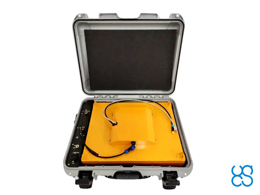
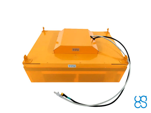
 Original price 38,989.00 USD - Original price 38,989.00 USDOriginal price38,989.00 USD38,989.00 USD - 38,989.00 USDCurrent price 38,989.00 USD
GPR Bundle: Radar Systems Zond Aero 1000 "NG" GPR
SPH EngineeringZond Aero 1000 "NG" GPR plus all required components and software for use with DJI M350/M300 drones (drone not included). For other types of drones...
View full detailsOriginal price 38,989.00 USD - Original price 38,989.00 USDOriginal price38,989.00 USD38,989.00 USD - 38,989.00 USDCurrent price 38,989.00 USD -
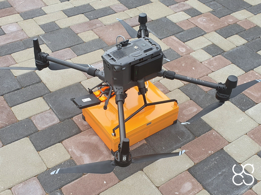
 Original price 20,690.00 USD - Original price 20,690.00 USDOriginal price20,690.00 USD20,690.00 USD - 20,690.00 USDCurrent price 20,690.00 USD
GPR system: Radar Systems Zond Aero 1000 "NG"
Radar SystemsLightweight GPR system, suitable for medium-sized drones like DJI M300/M350 RTK. NG in the name of device stands for "New Generation": that model u...
View full detailsOriginal price 20,690.00 USD - Original price 20,690.00 USDOriginal price20,690.00 USD20,690.00 USD - 20,690.00 USDCurrent price 20,690.00 USD -
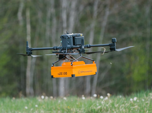
 Original price 0.00 USD - Original price 0.00 USDOriginal price 0.00 USD36,229.00 USD36,229.00 USD - 36,229.00 USDCurrent price 36,229.00 USD
GPR Bundle: Radar Systems Zond Aero 500 GPR
SPH EngineeringZond Aero 500 GPR plus all required components and software for use with DJI M350/M300/M600 drones (drone not included). For other types of drones,...
View full detailsOriginal price 0.00 USD - Original price 0.00 USDOriginal price 0.00 USD36,229.00 USD36,229.00 USD - 36,229.00 USDCurrent price 36,229.00 USD -
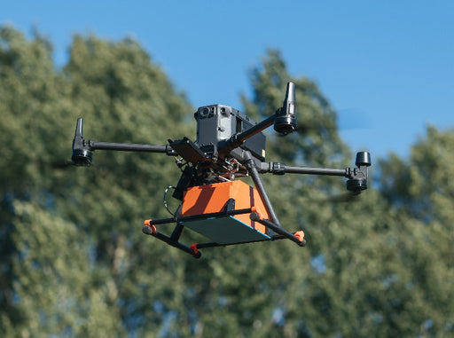
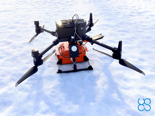
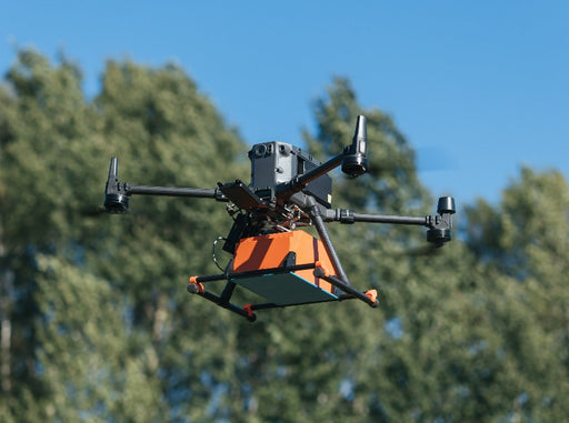
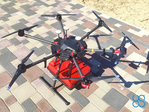
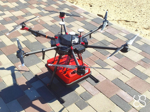
 Original price 17,930.00 USD - Original price 17,930.00 USDOriginal price17,930.00 USD17,930.00 USD - 17,930.00 USDCurrent price 17,930.00 USD
GPR system: Radar Systems Zond Aero 500
Radar SystemsLightweight GPR system, suitable for medium-sized drones like DJI M300 RTK. Includes a transportation box and mountings for the DJI M300/M350 RTK d...
View full detailsOriginal price 17,930.00 USD - Original price 17,930.00 USDOriginal price17,930.00 USD17,930.00 USD - 17,930.00 USDCurrent price 17,930.00 USD -
GPR system: Radarteam Cobra Drone CBD GPR
RadarteamAirborne version of the Radarteam Cobra CBD georadar system.Thanks to a special antenna, it has a very wide frequency range. HS Code: 90158020 (met...
View full details -
GPR system: Radarteam Cobra Plug-In GPR
RadarteamLow-frequency GPR system with 3 antenna options: SE-40: 52MHz SE-70: 80MHz SE-150: 124MHz HS Code: 90158020 (meteorological, hydrological, geoph...
View full details -
 Original price 3,496.50 USD - Original price 3,496.50 USDOriginal price3,496.50 USD3,496.50 USD - 3,496.50 USDCurrent price 3,496.50 USD
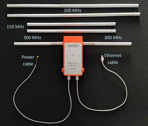
Radar Systems Zond Aero LF GPR - 50MHz antenna
SPH Engineering50MHz dipoles set for Radar Systems Zond Aero LF GPR. Set includes: 2x 50Mhz dipole (1.5m long) for Zond Aero LF 1x Plastic rod 3x Clamp type 1 (b...
View full detailsOriginal price 3,496.50 USD - Original price 3,496.50 USDOriginal price3,496.50 USD3,496.50 USD - 3,496.50 USDCurrent price 3,496.50 USD -
 Original price 3,170.00 USD - Original price 3,170.00 USDOriginal price3,170.00 USD3,170.00 USD - 3,170.00 USDCurrent price 3,170.00 USD
SkyHub software package for GPR
SPH EngineeringSoftware package for GPR integration. Includes firmware for SkyHub on-board computer and companion application for UgCS. Supports Radar Systems (Zo...
View full detailsOriginal price 3,170.00 USD - Original price 3,170.00 USDOriginal price3,170.00 USD3,170.00 USD - 3,170.00 USDCurrent price 3,170.00 USD -
 Original price 0.00 USD - Original price 0.00 USDOriginal price 0.00 USD5,380.00 USD5,380.00 USD - 5,380.00 USDCurrent price 5,380.00 USD
Training: Airborne GPR full course
SPH EngineeringThe combined course delivers knowledge necessary for efficient airborne GPR use - from mission planning to data interpretation. The course is offer...
View full detailsOriginal price 0.00 USD - Original price 0.00 USDOriginal price 0.00 USD5,380.00 USD5,380.00 USD - 5,380.00 USDCurrent price 5,380.00 USD -
 Original price 1,150.00 USD - Original price 1,150.00 USDOriginal price1,150.00 USD1,150.00 USD - 1,150.00 USDCurrent price 1,150.00 USD
Training: GPR on a UAV (GPR-1)
SPH EngineeringTraining for the users of Integrated Systems/GPR who already have at least basic UgCS experience. Training is dedicated to GPR application on UAVs....
View full detailsOriginal price 1,150.00 USD - Original price 1,150.00 USDOriginal price1,150.00 USD1,150.00 USD - 1,150.00 USDCurrent price 1,150.00 USD -
 Original price 770.00 USD - Original price 770.00 USDOriginal price770.00 USD770.00 USD - 770.00 USDCurrent price 770.00 USD
Training: GPR Basics (GPR-2)
SPH EngineeringTraining for users of Integrated Systems/GPR who don't have experience with GPR. Can be provided at the SPH Engineering office or using video confe...
View full detailsOriginal price 770.00 USD - Original price 770.00 USDOriginal price770.00 USD770.00 USD - 770.00 USDCurrent price 770.00 USD -
 Original price 1,540.00 USD - Original price 1,540.00 USDOriginal price1,540.00 USD1,540.00 USD - 1,540.00 USDCurrent price 1,540.00 USD
Training: GPR advanced module (GPR-3)
SPH EngineeringTraining for users of UgCS Integrated Systems/GPR wishing to dive deeper.Can be provided at the SPH Engineering office or using video conferencing ...
View full detailsOriginal price 1,540.00 USD - Original price 1,540.00 USDOriginal price1,540.00 USD1,540.00 USD - 1,540.00 USDCurrent price 1,540.00 USD -
 Original price 770.00 USD - Original price 770.00 USDOriginal price770.00 USD770.00 USD - 770.00 USDCurrent price 770.00 USD
Training: UgCS Basics
SPH EngineeringRecommended for new UgCS users. Can be provided at the SPH Engineering office or using video conferencing software. Duration: up to 4 hours. The pr...
View full detailsOriginal price 770.00 USD - Original price 770.00 USDOriginal price770.00 USD770.00 USD - 770.00 USDCurrent price 770.00 USD -
 Original price 1,150.00 USD - Original price 1,150.00 USDOriginal price1,150.00 USD1,150.00 USD - 1,150.00 USDCurrent price 1,150.00 USD
Training: UgCS AreaScan and True Terrain following missions
SPH EngineeringTraining is recommended for users of UgCS software and Integrated Systems who already have basic knowledge of UgCS. Training can be provided at th...
View full detailsOriginal price 1,150.00 USD - Original price 1,150.00 USDOriginal price1,150.00 USD1,150.00 USD - 1,150.00 USDCurrent price 1,150.00 USD -
 Original price 420.00 USD - Original price 420.00 USDOriginal price420.00 USD420.00 USD - 420.00 USDCurrent price 420.00 USD
Practical exam and certification: data collection, processing and interpretation
SPH EngineeringThe exam confirms practical knowledge and experience in data collection, processing and interpretation using systems supplied by SPH Engineering.Ho...
View full detailsOriginal price 420.00 USD - Original price 420.00 USDOriginal price420.00 USD420.00 USD - 420.00 USDCurrent price 420.00 USD -
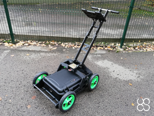
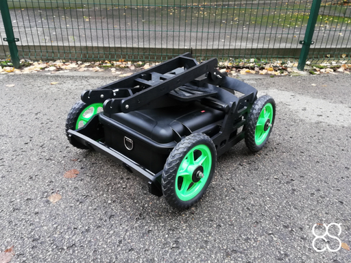 Original price 1,940.00 USD - Original price 1,940.00 USDOriginal price1,940.00 USD1,940.00 USD - 1,940.00 USDCurrent price 1,940.00 USD
GPR cart for terrestrial surveys for Zond GPR systems
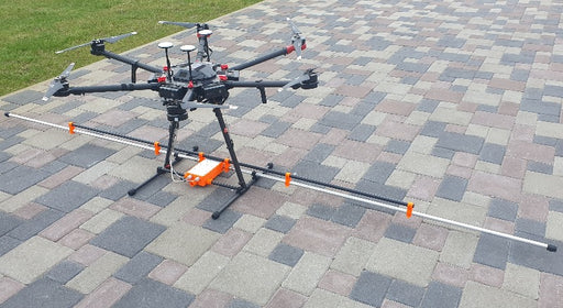
Radar SystemsLight, compact, shockproof trolley made of durable plastic, designed for surveys on asphalt/concrete or other hard surfaces. Built-in magnetic enco...
View full detailsOriginal price 1,940.00 USD - Original price 1,940.00 USDOriginal price1,940.00 USD1,940.00 USD - 1,940.00 USDCurrent price 1,940.00 USD


