Integrated Systems
-

 Original price 0.00 USD - Original price 0.00 USDOriginal price 0.00 USD29,699.00 USD29,699.00 USD - 29,699.00 USDCurrent price 29,699.00 USD
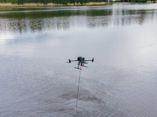
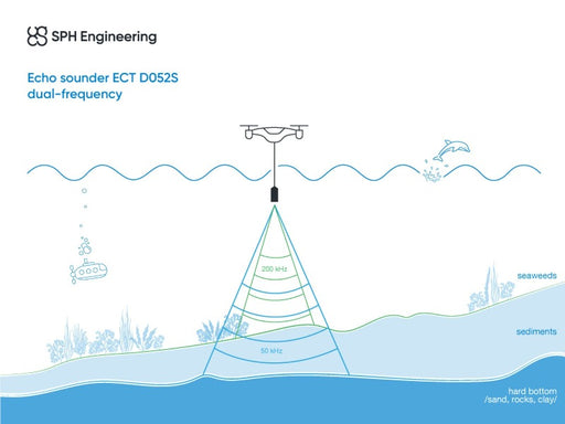
Echo sounder combo: ECT D052S dual-frequency
SPH EngineeringEchoLogger ECT D052S dual-frequency echo-sounder plus all required components and software for use with DJI M350/M300/M600 drones (drone not includ...
View full detailsOriginal price 0.00 USD - Original price 0.00 USDOriginal price 0.00 USD29,699.00 USD29,699.00 USD - 29,699.00 USDCurrent price 29,699.00 USD -

 Original price 0.00 USD - Original price 0.00 USDOriginal price 0.00 USD28,449.00 USD28,449.00 USD - 28,449.00 USDCurrent price 28,449.00 USD
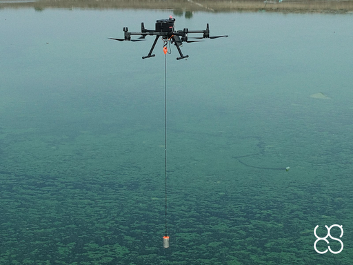
Echo sounder combo: ECT D24S dual-frequency
SPH EngineeringEchoLogger ECT D24S dual-frequency echo-sounder plus all required components and software for use with DJI M350/M300/M600 drones (drone not include...
View full detailsOriginal price 0.00 USD - Original price 0.00 USDOriginal price 0.00 USD28,449.00 USD28,449.00 USD - 28,449.00 USDCurrent price 28,449.00 USD -
 Original price 0.00 USD - Original price 0.00 USDOriginal price 0.00 USD27,409.00 USD27,409.00 USD - 27,409.00 USDCurrent price 27,409.00 USD
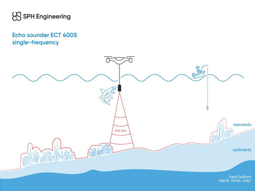
Echo sounder combo: ECT 400S single-frequency
SPH EngineeringEcho sounder combo: ECT 400S single-frequency EchoLogger ECT 400S single-frequency echo-sounder plus all required components and software for use w...
View full detailsOriginal price 0.00 USD - Original price 0.00 USDOriginal price 0.00 USD27,409.00 USD27,409.00 USD - 27,409.00 USDCurrent price 27,409.00 USD -

 Original price 9,390.00 USD - Original price 9,390.00 USDOriginal price9,390.00 USD9,390.00 USD - 9,390.00 USDCurrent price 9,390.00 USD
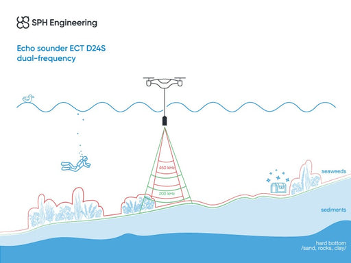
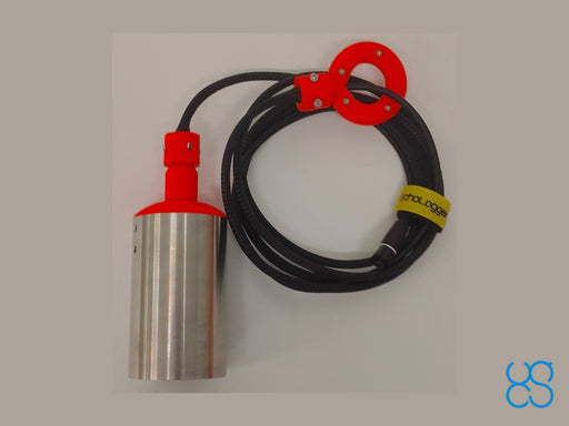
EchoLogger ECT D24S echo sounder
EchoLoggerEchoLogger ECT D24S dual-frequency echo sounder with tilt and temperature sensor, harness, housing, and mountings for the drone. The echo sounder c...
View full detailsOriginal price 9,390.00 USD - Original price 9,390.00 USDOriginal price9,390.00 USD9,390.00 USD - 9,390.00 USDCurrent price 9,390.00 USD -
 Original price 10,640.00 USD - Original price 10,640.00 USDOriginal price10,640.00 USD10,640.00 USD - 10,640.00 USDCurrent price 10,640.00 USD
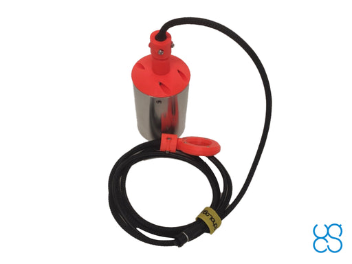
EchoLogger ECT D052S echo sounder
EchoLoggerEchoLogger ECT D052S dual-frequency echo sounder with tilt and temperature sensor, harness, housing, and mountings for the drone. The echo sounder ...
View full detailsOriginal price 10,640.00 USD - Original price 10,640.00 USDOriginal price10,640.00 USD10,640.00 USD - 10,640.00 USDCurrent price 10,640.00 USD -
 Original price 8,350.00 USD - Original price 8,350.00 USDOriginal price8,350.00 USD8,350.00 USD - 8,350.00 USDCurrent price 8,350.00 USD
EchoLogger ECT 400S echo sounder
EchoLoggerEchoLogger ECT 400S echo sounder with tilt and temperature sensor, harness, housing, and mountings for the drone. The echo sounder cable is protect...
View full detailsOriginal price 8,350.00 USD - Original price 8,350.00 USDOriginal price8,350.00 USD8,350.00 USD - 8,350.00 USDCurrent price 8,350.00 USD -
 Original price 3,170.00 USD - Original price 3,170.00 USDOriginal price3,170.00 USD3,170.00 USD - 3,170.00 USDCurrent price 3,170.00 USD
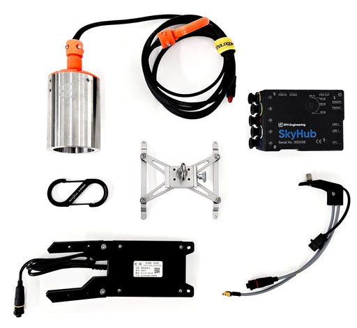
SkyHub software package for echo sounder
SPH EngineeringSoftware package to support single and dual-frequency echo sounders. Includes firmware for SkyHub on-board computer and companion application for U...
View full detailsOriginal price 3,170.00 USD - Original price 3,170.00 USDOriginal price3,170.00 USD3,170.00 USD - 3,170.00 USDCurrent price 3,170.00 USD -
 Original price 770.00 USD - Original price 770.00 USDOriginal price770.00 USD770.00 USD - 770.00 USDCurrent price 770.00 USD
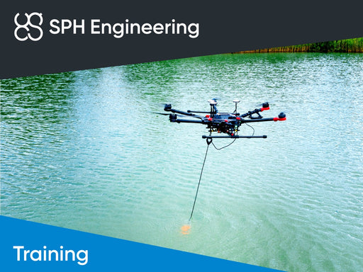
Training: Bathymetric data collection using drone (BATHY-1)
SPH EngineeringOnly one of its kind training to learn how to perform bathymetric surveys with echo sounders integrated with a drone.Students should have the knowl...
View full detailsOriginal price 770.00 USD - Original price 770.00 USDOriginal price770.00 USD770.00 USD - 770.00 USDCurrent price 770.00 USD -
 Original price 770.00 USD - Original price 770.00 USDOriginal price770.00 USD770.00 USD - 770.00 USDCurrent price 770.00 USD
Training: Bathymetric data processing (BATHY-2)
SPH EngineeringOnly one of its kind training to learn how to process bathymetric data gathered with echo sounders integrated with a drone. Training is deducated f...
View full detailsOriginal price 770.00 USD - Original price 770.00 USDOriginal price770.00 USD770.00 USD - 770.00 USDCurrent price 770.00 USD -
 Original price 420.00 USD - Original price 420.00 USDOriginal price420.00 USD420.00 USD - 420.00 USDCurrent price 420.00 USD
Practical exam and certification: data collection, processing and interpretation
SPH EngineeringThe exam confirms practical knowledge and experience in data collection, processing and interpretation using systems supplied by SPH Engineering.Ho...
View full detailsOriginal price 420.00 USD - Original price 420.00 USDOriginal price420.00 USD420.00 USD - 420.00 USDCurrent price 420.00 USD -
 Original price 2,310.00 USD - Original price 2,310.00 USDOriginal price2,310.00 USD2,310.00 USD - 2,310.00 USDCurrent price 2,310.00 USD
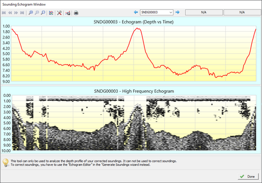
Eye4Software B.V. Hydromagic Survey
Eye4SoftwareComputer bound license (two computers maximum). Hydromagic Survey is a professional hydrographic survey package, which can be used to map depth are...
View full detailsOriginal price 2,310.00 USD - Original price 2,310.00 USDOriginal price2,310.00 USD2,310.00 USD - 2,310.00 USDCurrent price 2,310.00 USD -

 Original price 350.00 USD - Original price 350.00 USDOriginal price350.00 USD350.00 USD - 350.00 USDCurrent price 350.00 USD
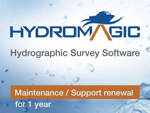
Eye4Software B.V. Hydromagic Survey Maintenance / Support renewal for 1 year
Eye4SoftwareAnnual support and update pack for Hydromagic Survey.Provide access to any technical inquiries as well as access to new versions.
Original price 350.00 USD - Original price 350.00 USDOriginal price350.00 USD350.00 USD - 350.00 USDCurrent price 350.00 USD -
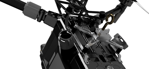
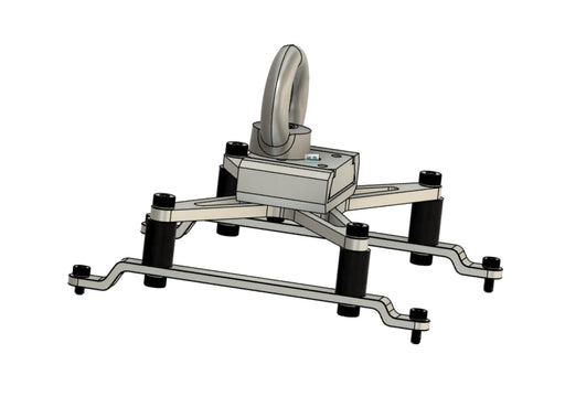 Original price 370.00 USD - Original price 370.00 USDOriginal price370.00 USD370.00 USD - 370.00 USDCurrent price 370.00 USD
Universal heavy lift payload mounting for DJI M300/M350 RTK drone
TopodroneUniversal mountings for payloads on ropes/cables: echo sounders, water samplers, etc. Also compatible with some types of LIDAR payloads.
Original price 370.00 USD - Original price 370.00 USDOriginal price370.00 USD370.00 USD - 370.00 USDCurrent price 370.00 USD


